
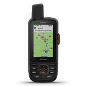


Garmin GPSMAP 66i GPS Handheld and Satellite Communicator
Rugged GPS Handheld and Satellite Communicator with Garmin TOPO Mapping. Precise Garmin navigation meets global communication in the GPSMAP 66i premium GPS handheld with inReach satellite technology.
- Large 3″ Sunlight-readable color display for easy viewing
- Trigger an interactive SOS to the geos 24/7 search and rescue monitoring center; two-way messaging via the 100% Global Iridium satellite network (satellite subscription required)
- Preloaded Garmin TOPO mapping with direct-to-device Birdseye satellite imagery downloads (no annual subscription); includes multiple global navigation satellite systems (GNSS) support and navigation sensors
- Cellular connectivity lets you access active weather forecasts and geocaching live
- Compatible with the Garmin explore website and app to help you manage waypoints, routes, activities and collections, use tracks and review trip data from the field


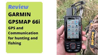


National Park Photographer –
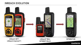
There are now four Garmin GPS handhelds with InReach messaging via the Iridium satellite network. Here is a quick listing of the models followed by a more detailed description of their pros and cons.GPSMAP 66i – Added InReach satellite Messaging, SOS, and Weather forcasts to the already successful GPSMAP 66st. But this has the lowest battery life of existing InReach models with 35 hours under normal use.InReach Explorer+ – The longest lasting (100 hours) InReach with 24k maps of North America and navigation built-in.InReach SE+ – The same long lasting InReach as the Explorer+ but without built-in maps and navigation.InReach Mini – A small version of the SE+ with half the battery life, half the size, and weight.First let’s get some basics out of the way. Buy this or one of the other InReach models if you expect to be beyond cell coverage. It could SAVE YOUR LIFE. The InReach two-way satellite messaging feature costs more to buy than a GPS receiver alone and requires a subscription for the messaging feature, like all utilities, phone, cable, electricity, etc. Also please realize that messaging is a two-way process. Unlike GPS which only receives location Info from satellites, messaging must send your message high into space and therefor needs lots of battery power. All InReach models will send and receive text (SMS) and email messages to anyone in the World with a phone that can get normal texts and emails. But it will take longer than Cell texting which uses a grid of towers nearby just waiting to take your message and pass it on. However, there are no Cell towers in the wilderness or out at sea. The InReach uses the Iridium system of over 70 satellites which each take about 90 minutes to make one circle of the Earth. At any time, the chance of your device communicating with a satellite depends on if a satellite is passing, how much unobstructed sky is above, and if your InReach is “Looking” to communicate. Simply put, if you want the best chance of quicker communications get into an open space where the chance of “seeing” a passing satellite or two is greater and tell your InReach to check for messages. Bottom line, messages take time to send and receive. Millions of messages and tracking locations have been successfully sent and the InReach SOS system has had over 3000 search and rescue responses. It’s very reliable if you understand how to use it properly. Your next best option is smoke signals. Please also be assured that if you carry a smartphone (iOS or Android) the included EarthMate app will provide detailed topo maps of North America and link to any InReach model to make typing messages easy using the phone’s touch keyboard. So, even if the InReach does not have BUILT-IN maps you still have it all with EarthMate on your phone without any cell or Internet connection.I have used the GPSMAP 66i and each of the other Garmin InReach handhelds. Here are my recommendations for their best and less useful features and who would benefit most from each. My tests have shown that they all perform equally for sending and receiving satellite messages. And the cost of the messaging service subscriptions is the same for all models. Here is a list the major differences and what each means.The GPSMAP 66i is built on the proven GPSMAP system of GPS handhelds. It uses Garmin’s system of device integration and coordination. It is the first InReach to completely break free from the original DeLorme system after Garmin took over. Read the GPSMAP 66st manual online for a full understanding of all that this system will do. PROS: Full InReach technology including messaging, SOS, and satillite weather forecasts, A larger screen. Extensive WiFi and Bluetooth connectivity to other Garmin watches, sensors, and health devices. Ability to store, classify, and share activity, routes, waypoints, and other data via the Garmin cloud. The built-in TopoActive map supports turn-by-turn prompts on the trail when using a route and has lots more short local trails than that in the Explorer+ which requires you to download additional OpenStreetMaps directly into its built-in free space or into a paired phone for more local trails. You can download directly into the GPSMAP 66i free, but poor resolution BirdsEye Satellite Imagery to overlay your topo maps with actual photo data. With the optional City Navigator North America NT map ($80) the GPSMAP 66i can be set to look and act just like a dedicated road GPS for driving. It includes thousands of points of interest (shopping, lodging, travel etc.) that can be searched and navigated to with on-road turn by turn calculation. The only features found in dedicated automobile GPS devices that it doesn’t have are voice notifications for upcoming turns (it uses tones) and traffic conditions. Even so, this lets you buy just one device that will work very well on the road as well as the trail. CONS: The BATTERY LIFE IS ONLY 35 HOURS under normal usage. This, like all InReach devices, this can be substantially extended by careful planning. But this is a poor choice for multi-day off-grid excursions due to the limited battery life. All those handy GPSMAP features take energy and many are of no use in the wilderness beyond cell or WiFi access. BEST FOR: People who like the full featured Garmin fitness and activity gear, welcome access to Garmin maps and the Garmin cloud systems, like BirdsEye photo imagery directly in the device without a phone, and don’t often venture into the backcountry for more than a long weekend. Please understand that most of the GPSMAP features beyond the InReach messaging, weather, and SOS go away when you go beyond the cell system. Most important, conserve the battery or bring along an external battery recharging pack in case of an emergency and the need to text with GEOS and rescue responders. This is Garmin’s current Top of the Line GPS handheld due to its many features and InReach technology. It’s a great choice for most casual hikers, boaters, and hunters.The Explorer+ is in my opinion the best handheld for anyone who plans to be beyond Cell coverage for more than a couple of days. It will last 100 hours under normal conditions and over a month with careful planning. Like the GPSMAP 66i it has a built-in map of North America with robust navigation features. However this is NOT a TopoActive map with the ability to have turn-by-turn prompt tones like the map in the GPSMAP 66i. This unit can stand alone long after your phone dies. PROS: Long battery life, built-in 24k topo map of North America, weather forecasts from the backcountry via the satellite system. Built-in digital compass, accelerometer, and altimeter for precise location and bearing info without the need to be moving. The Explorer+ can store additional maps, contacts, routes, and waypoints internally after syncing at home. CONS: Not compatible with Garmin’s fitness, exchange systems, and TopoActive maps like the GPSMAP 66i. BEST FOR: Long distance hikers, hunters, and boaters who expect to be beyond cell service for many days and want to be able to navigate without the need to use a phone.The InReach SE+ Same size and satellite messaging as the Explorer+ but without the Map and Navigation features. PROS: 100 hour battery for messaging, SOS, and satellite based weather forecasts. Same rugged case and waterproof standard as the explorer+. CONS: Only $50 less than the Explorer+. In my opinion spending that little bit of extra money gets you a lot more value in navigation and location capability in the Explorer+. BEST FOR: Those who only want off-grid communications, SOS, and long battery life for extended use.The InReach Mini is the smallest, lightest, and most difficult to use in a stand-alone mode. But pair it to a smartphone and you have both easy messaging with contacts, routes, and waypoints available as well as a free full features topo map of North America. PROS: Small and light. Easy to carry with you at all times for when the car dies in a cell dead zone, satellite messages, weather forecasts, and SOS. CONS: Tedious to write messages from the device. Only 50 hours of battery under normal use. This is half of the battery life of the Explorer+ or SE+. No built-in map for navigation. Must pair to your smartphone to see a map and navigate. But cell phones won’t last as long. When they lose battery, navigation goes also. The Mini although lighter and smaller will need a phone to navigate and a battery pack to recharge both devices thus adding to the total size and weight. BEST FOR: People who just want to be able to communicate from beyond cell service for convenience or safety in emergencies and like the fact that when connected to a phone running the EarthMate app it provides a great detailed map and navigation. Those who appreciate its small size and weight and don’t feel a need for extended battery life. The average day or weekend hiker, hunter, or boater who likes the security of weather forecasts in the wilderness, two-way SOS, and the ability to keep in touch with home. Anyone who wants to get help from a dead cell zone when things go wrong.Which model is best for you? If you are a long distance, multi-day hiker, hunter, or offshore boater the Explorer+ is the best choice for you. It’s long battery life and additional downloadable maps and NOAA charts to your phone give you everything you need for many days off grid. Keep in mind that you should plan to save 25% of your battery in case of a SOS emergency and the need to communicate with GEOS and rescue responders.If you hike on weekends or the occasional vacation for just a few days the InReach SE+ or Mini will serve you well for messaging, satellite weather forecasts, and SOS. Remember these don’t have built-in navigation so bring along your smartphone with the free EarthMate app installed. Anyone who wants the ability to get help or just reach out to family or friends from dead Cell areas should consider the Mini. It’s small, easy to carry and always there when you need it. And, an minimum Annual Subscription is well worth the peace of mind.If you are an active biker, runner, or other sport enthusiast who spends most of the time within the Cell system range but likes weekends or a few days in the wild you might consider the GPSMAP 66i. It costs more, but it does integrate with the existing Garmin systems that support inter-device sharing, WiFi apps, and many other features that won’t work in the wilderness but are helpful when you are back in your home base. Its built-in map also has lots of short local trails without the need to add OpenStreetMaps. Its ability to use TopoActive turn-by-turn prompted maps for pre-defined routes can be helpful to insure you don’t miss a vital turn. And if you need a full-featured automotive GPS navigator adding the Garmin City Navigator North America NT map ($80) will save paying hundreds for a second device.Final Answer… All of these InReach included devices will let you send and receive texts or emails from anywhere to anyone, get weather forcasts anywhere via the satillites, and get help for any emergency from a flat tire to a broken leg in the wilderness. They all work equally well. The service plans are priced for every budget. The cheapest plan is less than $15 per month. I pay more than that in one day for my coffee and pastry breaks. The unlimited plan tops off at under $70 per month if you want the ability to deactivate the device and not pay for the months you won’t need it. Annual Contract plans which keep the device active at all times are cheaper per month. As an example, I carry a MINI at all times on the Annual Safety plan for $13 per month. This gives me the peace of mind of knowing I can communicate when the car breaks down in a dead cell zone. GEOS will call my roadside assistance provider for me if I press the SOS button. Or I can text a family member to help. I also have an Explorer+ for those multi-day backcountry photo expeditions where long battery life is critical. The Explorer+ is on the Freedom Expedition plan at $70 per month with unlimited messages but only for the months that I need it.Hopefully this has been helpful. Please choose the best InReach device for your needs and budget. Is it worth the cost? Consider the consequences of being unable to communicate when misfortune hits you or someone you meet on the trail or at sea. Many lives have been saved by the InReach since it was developed. No matter which choice you make remember to stop and enjoy the view.
Honest Reviewer –
Pros:__________• Very light, one half-pound, to put in your bag that doesn’t take up much room.• The screen is a decent size, and bright enough to reduce any glare on a sunny day.• Even in the middle of nowhere, with no phone, you can send and receive text messages, as well as emails, with this device.• The navigation is fully immersed with this device. Besides the GPS mapping of your location, the system comes with waypoint creations, tracking, routes, and points of interests (shopping, gas stations, numerous stores, etc.) on the road.• It’s built of the outdoors so dropping it, getting it dirty, or wet, will not affect its performance.• A rechargeable battery system.• You can navigate all your info on the device onto a computer, as it does have a built-in USB connector (will charge it as well).• You don’t need clear skies to use this device. It worked fine inside my home. I know it’s advised that the best performance is to use this with clear skies, but it works either.• There is a simple SOS button that will alert rescues authorities to your exact location. No need to scramble around the screen and the SOS feature is right in front of you.• The back end, of the online feature, is a great perk to have. You can allow anyone you want to let them know where you’re at in the world. All they have to do is go online and track where you’re at, even if you never press the SOS notification.• You can still use the GPS navigation without activating the subscription service, or the need for internet connection.• The app, EarthMate, with this device, is useful as well because you can connect, via Bluetooth, with on your phone and use the layout/perks of device. I see this a must if you want to send a text message or an email. Using your smartphone for this will be 10x faster in typing on the device itself.• Connecting to the app, you don’t need any internet or cellular connection.Cons and Oks:__________• The messaging system does require a subscription service to use all the communications capabilities, and it ain’t cheap.• No voice notifications to make sure you’re going the right direction. This is also a downer if you want to use this while driving, but it does use tones.• For something to be taken into the wilderness, the battery life isn’t great. Only 3 days of use of normal usage (GPS only). If you don’t bring an extra battery extension then you do have limits on where you want to go, if you’re planning to spend more than 3 days in the wild.• You’re unable to store contacts and get weather updates with this. Weather updates is a huge upset, but the company has stated that new firmware updates will fix both these problems.• The response time on sending and receiving messages can take minutes to hours. It’s not using cellar towers, but satellites to send your info. This means the device is waiting for a satellite to be in reach to send the info. Depending where you’re at, it can take a while, and therefore drain your battery significantly. It keeps retrying and retrying until it completes its task.Bottom Line:__________Any traveling that brings you off the grid, you need one of these. You can’t go wrong with this device as it does exactly what it says it can do. From GPS tracking to allow your loved ones to know where you’re at, at all times. For a 2 day journey, this is a great security blanket to have.But still, nothing is too good to be true. With price there asking, you expect more in battery life. The battery life restricts how deep you want to get lost, and the subscription service does put a damper on those hoping to message loved ones, without paying a monthly service for it. One huge issue I hope they’ll fix is getting weather info on this device. Nature is brutal and weather can change within minutes. If they put some firmware updates to resolve these problems than I think it’s something to consider in investing in.Overall: An average battery life integrated into an excellent GPS tracker (with some limits).Hope I was a help to you.Love,Honest Reviewer.
Luca Rotella –
So far I am really liking my Garmin GPSMap 66i. There is definitely a learning curve if you want to figure out everything this unit has to offer. The basics of planning a route and making tracks is pretty straight-forward. I would suggest that you take a week or so of playing with it close to home before taking it into the field.Like most GPS units, figuring it out “on the fly” can prove to be disappointing. Plan a route using the Basecamp app (free download from Garmin) and record some routes and mark some waypoints. You can do a lot right on the unit, but Basecamp greatly simplifies the process and makes it easier to visualize.And, of course, the reason you would want this unit is for the InReach capability of satellite communications. There is a learning curve to this also. I was able to start my subscription, set up the pre-set text communications, and test all of this without any calls or communications with Garmin or InReach. That being said, I spent quite a bit of time noodling around the Garmin/InReach sites, Google, and of course, the University of YouTube. I am not the brightest bulb in the closet, so it did take quite a few hours for me to put it all together. But, the info is definitely out there to get it done. When I tested it at home and in the field, the text messages came through pretty quickly (around a minute).Overall, I am impressed and am going to press on and figure all that this unit has to offer. Next, Geocaching…..